Слайд 2Presentation plan
General information about possible geopark including
The Puchezh-Katunki impact crater and red

brechia dislocations
The Prosek Upper Bathonian deposit
The landscape at the confluence of the Oka and Volga rivers
General information about possible urbanizing project at the confluence as alternative to geopark project
Multi-Criteria evaluation of two alternative projects
Discussion and conclusion
Слайд 3Why Geopark?
Geoparks are based on unique experience of nature use evolving habits,

ways, literature, music and arts.
Geoparks are drivers of a low carbon economic development, involving the local population in it and creating markets for post-industrial goods and services based on network technologies.
Geopark is a site for multidisciplinary scientific research
Geopark has its special role in education including both Earth sciences and anthropological sciences based on culture, history and Geo heritage economy
Geoparks belong to the global network of educational and scientific tourism and local conventional economy to attract both residents and guests
Geoparks are inherently the prototype of the civilization of the future.
Слайд 4General information about geological heritage of the region
The most famous Geo Heritage

site of the region is the Puchezh-Katunki impact crater of an early Jurassic age.
The Puchezh-Katunki dislocation belongs to top ten Earth objects of asteroid origin
The Bathonian-Callovian deposits of the Jurassic system near the settlement of Prosek on the banks of the Cheboksary reservoir is considered as «the golden nail» of the Jurassic stratigraphy
The landscape at the confluence of Oka and Volga rivers was created by water flows in the postglacial period. The landscape is considered as the most beautiful Russian landscape
Слайд 5Geological sites at
Nizhny Novgorod region

Слайд 6
Geopark at the confluence of the Oka and Volga Rivers
Scenario 2

Слайд 7Breccia of the Puchezh-Katunki permian dislocation (photo by Аnton Ulyakhin)

Слайд 8The Prosek Upper Bathonian deposit

Слайд 9UNIQUE LANDSCAPE AT THE OKA AND
VOLGA RIVERS CONFLUENCE
Oka
Volga

Слайд 10SPRING ICE MELTING AT THE CONFLUENCE
Oka
Volga

Слайд 11NIZHNY NOVGOROD AS A REGALLY POSED CITY
Oka
Volga
The height difference between the

left floodplain and right steep banks is 150 m
The height difference was formed under the influence of melt water
after the melting of glaciers
Слайд 12NIZHNY NOVGOROD AS
A REGALLY POSED CITY

Слайд 13URBANIZING PROJECTS
AS ALTERNATIVE TO GEOPARK
SCENARIO 1

Слайд 14URBANIZING PROJECTS
ON THE LEFT BANK OF THE VOLGA RIVER
Globe town with

population 400…500 thousand
(2009)
The project was postponed
No investors were found
Слайд 15A NEW VERSION OF FLOODPLAIN
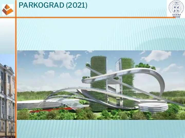
URBANIZATION NAMED PARKOGRAD (2021)
Volga
The project of the

biggest university campus and IT village
(70 000 students,
30 000 campus employers,
40 000
IT employers)
Слайд 18Oka
MULTI-CRITERIA EVALUATION OF TWO ALTERNATIVE PROJECTS

Слайд 19Oka
IMPACT MATRIX –
SYSTEM STRUCTURAL ANALYSIS
Ten variables were selected by the team
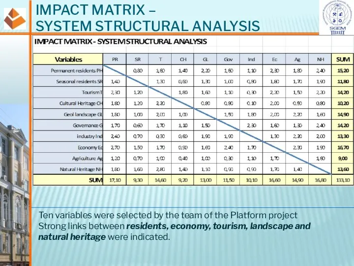
of the Platform project
Strong links between residents, economy, tourism, landscape and natural heritage were indicated.
Слайд 20CAUSE AND EFFECTS
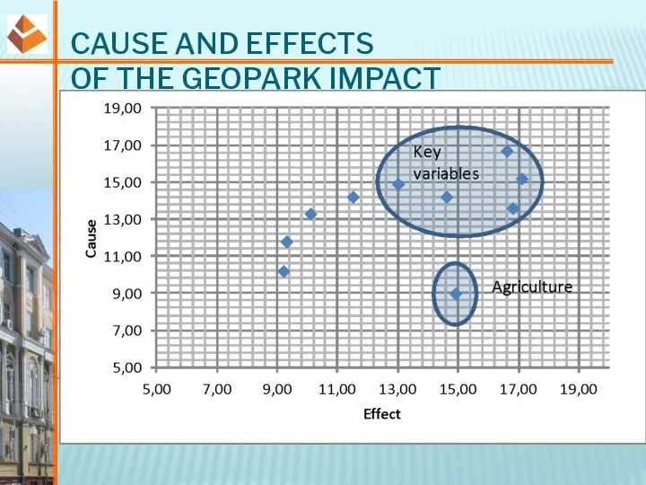
OF THE GEOPARK IMPACT
Слайд 21WEIGHTING MATRIX FOR MCE
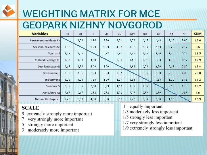
GEOPARK NIZHNY NOVGOROD
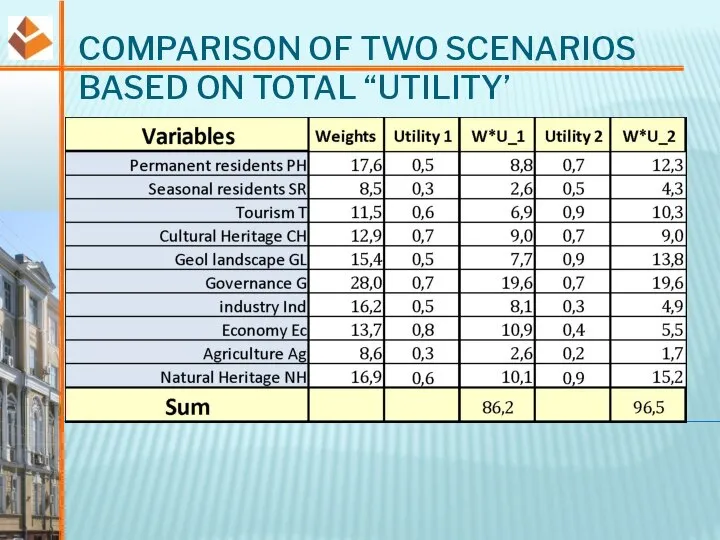
Слайд 22COMPARISON OF TWO SCENARIOS BASED ON TOTAL “UTILITY’
Слайд 23CONCLUSION (1)
The use of the MCE and the Brunswik’s approach made possible
to form a deeper and critical insight of processes in the Nizhny Novgorod agglomeration.
In particular, the key role of tourism, natural heritage and landscape was indicated.
The shrinking role of local agriculture and industry is important for low carbon transformation.
Our experts ranked natural heritage higher than cultural heritage. May be because they were focused on geological and natural heritage conservation. It looks amazing for the agglomeration with more than one hundred cultural monuments and sites. A new value is being formed in the public consciousness This is cultural landscape integrating natural landscape of high value and human creations.
Слайд 24CONCLUSION (2)
The weighting matrix analysis showed that there is some support in
society for a more utilitarian projects based on modern construction technologies in difficult hydrological conditions.
This approach creates huge urban areas on floodplains in the vicinity of the river. The unique natural landscape will be lost.
The MCE performed in presentation suggests that for the selected variables and team of experts the option of creating a Geopark looks more preferable. For more reliable conclusions, further research is required.
Слайд 25CONCLUSION (3)
According to the results obtained scenario 2 looks more attractive for
the population and for the regional economy.
At the same time, a number of uncertainties in the assessment remain.
How can the result change with the expansion of expert team?
How does new variables change the final evaluation?
How does utility1 and utility2 refining change the final evaluation?
The authors hope to pursue these questions in discussions at SGEM workshop on 17-18th August
You are welcome!




 What do you see
 Methods of Teaching Writing. How to Teach Writing
 Способы сказать ДА, НЕТ, НАВЕРНОЕ
 Past simple и continuous
 This \ That is a _____
 Good habits
 Glossary
 Презентация на тему Личные местоимения. Глагол to be
  Plurals 2. English plot
 The story of Miss Moppet by Beatrix Potter
 Spotlight_7_2a
 Memory school
 In a musuem
 Оборот There is/There are
 Sights of London
 Hickory, dickory, dock
 Sergey Viktorovich Lavrov. The Foreign Minister of Russia
 Articles. Some adjectives to know
 Holiday problems. Vocabulary
 Мне точно не нужен английский?
 Speak, talk, tell, say
 Food Verbs
 Конструкция There is / There are
 Films Adjectives
 Present Perfect
 The Box
 Shopping list
 The fifth of April Class Work “Can I help“