- road monitoring 2020

Содержание
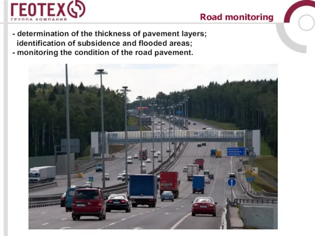
- 2. Road monitoring - determination of the thickness of pavement layers; identification of subsidence and flooded areas;
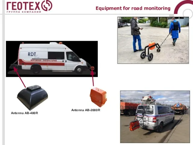
- 4. Equipment for road monitoring Antenna АB-2000R Antenna АB-400R
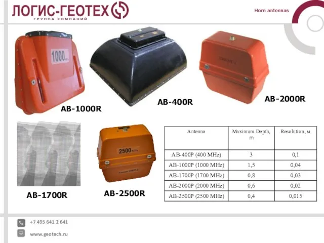
- 5. +7 495 641 2 641 www.geotech.ru Horn antennas АB-1000R АB-400R АB-1700R АB-2500R АB-2000R
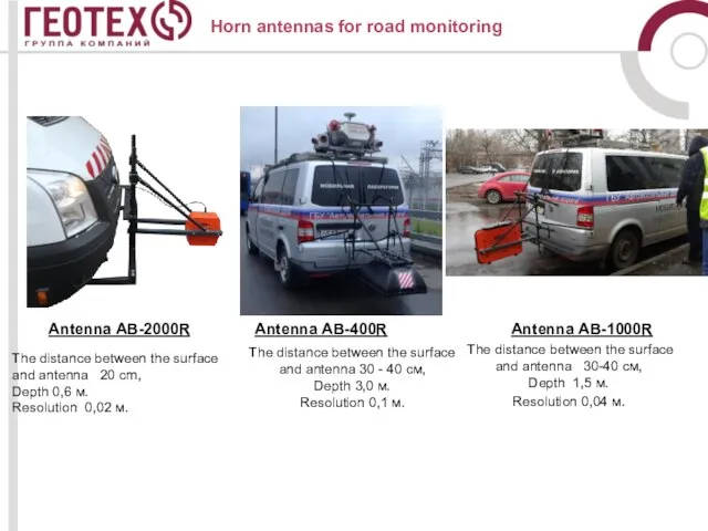
- 6. Antenna АB-2000R Antenna АB-400R Antenna АB-1000R The distance between the surface and antenna 20 cm, Depth
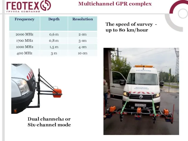
- 7. Multichannel GPR complex The speed of survey - up to 80 km/hour Dual channelы or Six-channel
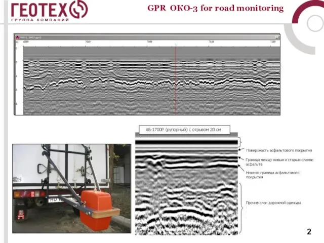
- 8. GPR ОКО-3 for road monitoring
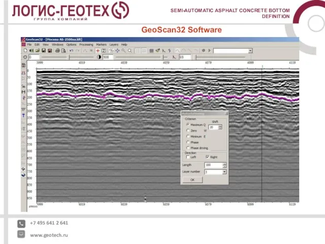
- 9. +7 495 641 2 641 www.geotech.ru SEMI-AUTOMATIC ASPHALT CONCRETE BOTTOM DEFINITION GeoScan32 Software
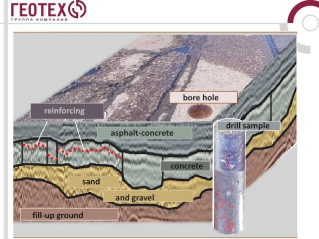
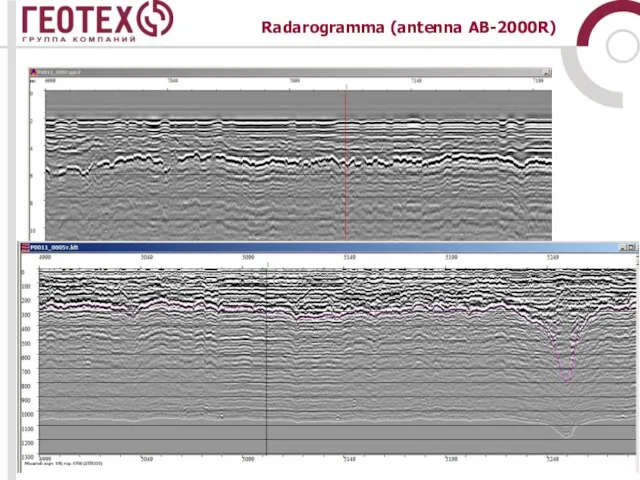
- 10. Radarogramma (antenna AB-2000R)
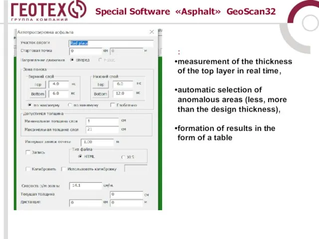
- 11. Special Software «Asphalt» GeoScan32 : measurement of the thickness of the top layer in real time,
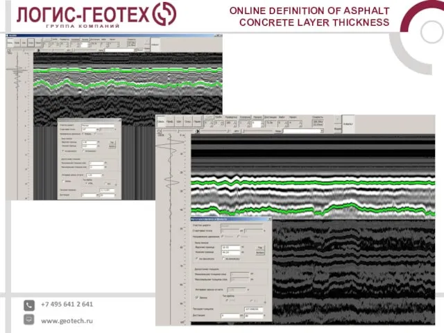
- 12. +7 495 641 2 641 www.geotech.ru ONLINE DEFINITION OF ASPHALT CONCRETE LAYER THICKNESS
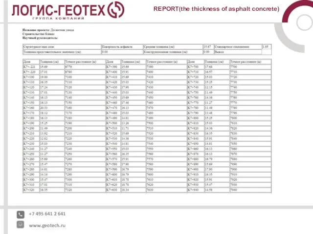
- 13. +7 495 641 2 641 www.geotech.ru REPORT(the thickness of asphalt concrete)
- 14. +7 495 641 2 641 www.geotech.ru Determination of soil heterogeneity and structural layers, pavement. Acceleration of
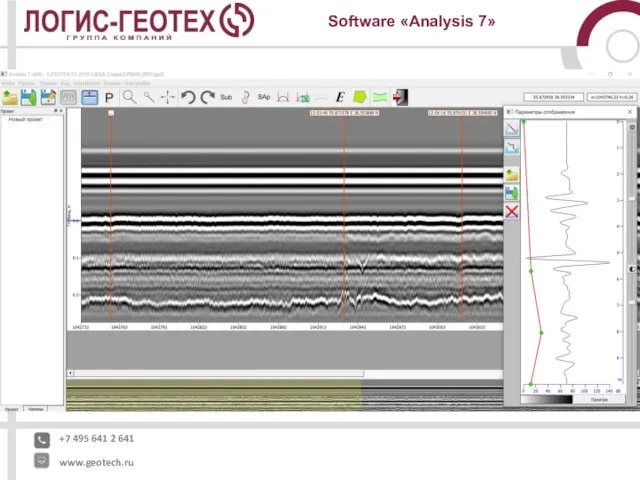
- 15. +7 495 641 2 641 www.geotech.ru Software «Analysis 7»
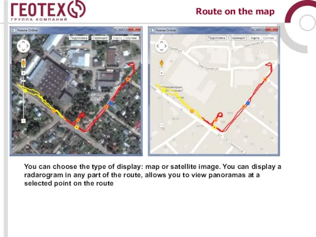
- 16. Route on the map You can choose the type of display: map or satellite image. You
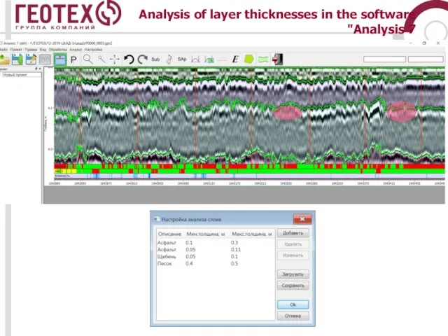
- 17. Analysis of layer thicknesses in the software "Analysis 7
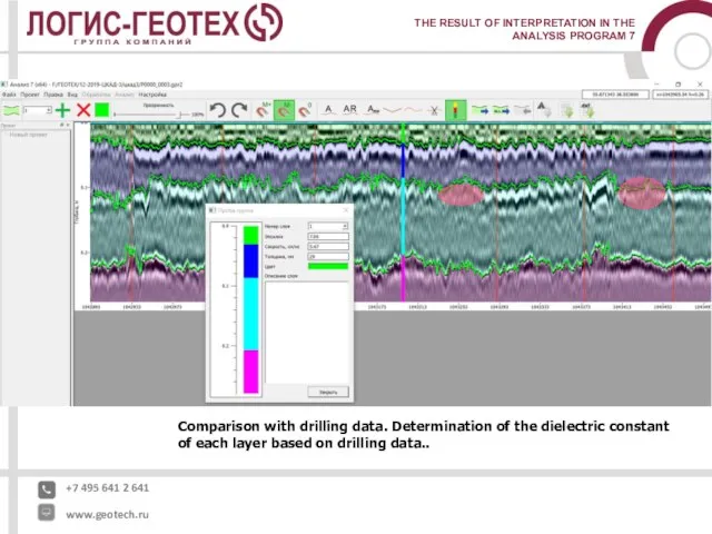
- 18. +7 495 641 2 641 www.geotech.ru THE RESULT OF INTERPRETATION IN THE ANALYSIS PROGRAM 7 Comparison
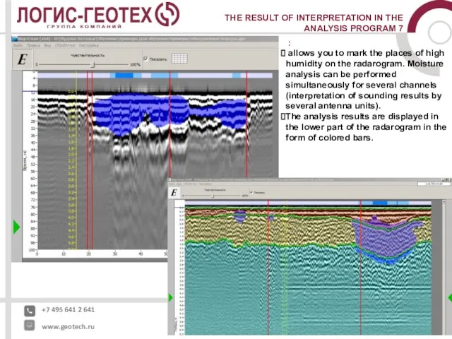
- 19. +7 495 641 2 641 www.geotech.ru THE RESULT OF INTERPRETATION IN THE ANALYSIS PROGRAM 7 :
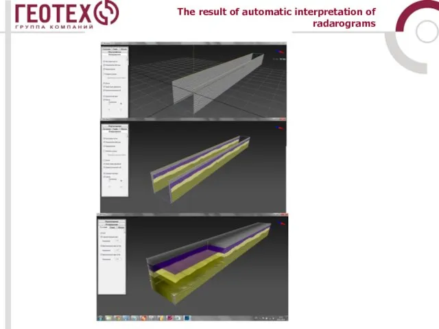
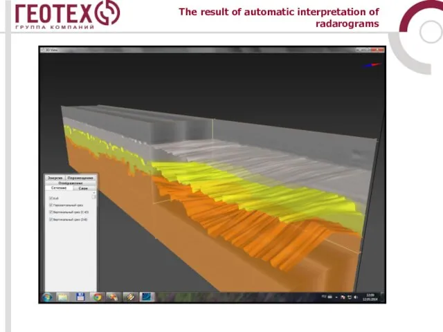
- 20. The result of automatic interpretation of radarograms
- 21. The result of automatic interpretation of radarograms
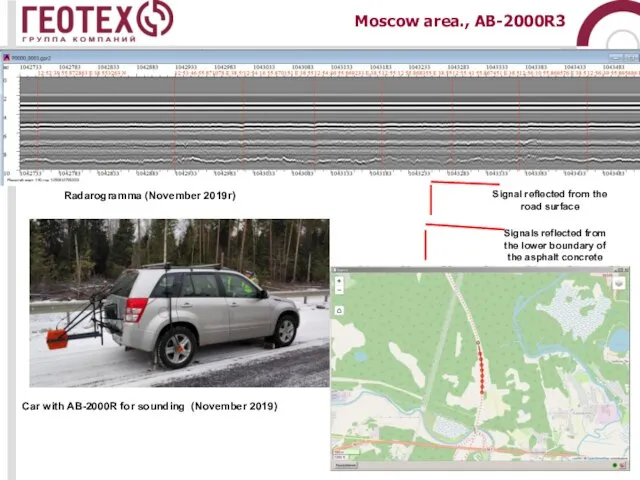
- 22. Moscow area., АB-2000R3 Radarogramma (November 2019г) Car with AB-2000R for sounding (November 2019) Signal reflected from
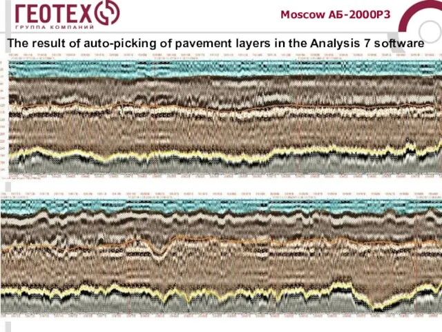
- 23. The result of auto-picking of pavement layers in the Analysis 7 software Moscow АБ-2000Р3
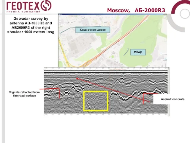
- 24. Moscow, АБ-2000R3 Signals reflected from the road surface Asphalt concrete Georadar survey by antenna AB-1000R3 and
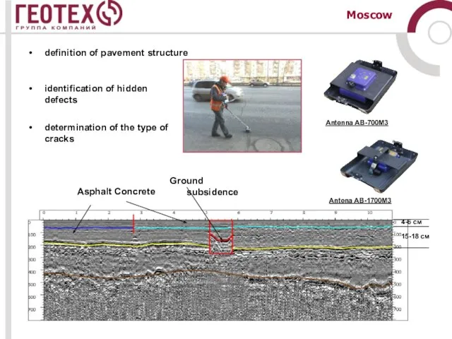
- 25. Moscow definition of pavement structure identification of hidden defects determination of the type of cracks Asphalt
- 26. Cracks, voids….
- 27. Moscow Asphalt concrete layer boundary
- 28. Moscow Crack location on the surface Asphalt concrete bottom boundary Reflection from a crack in the
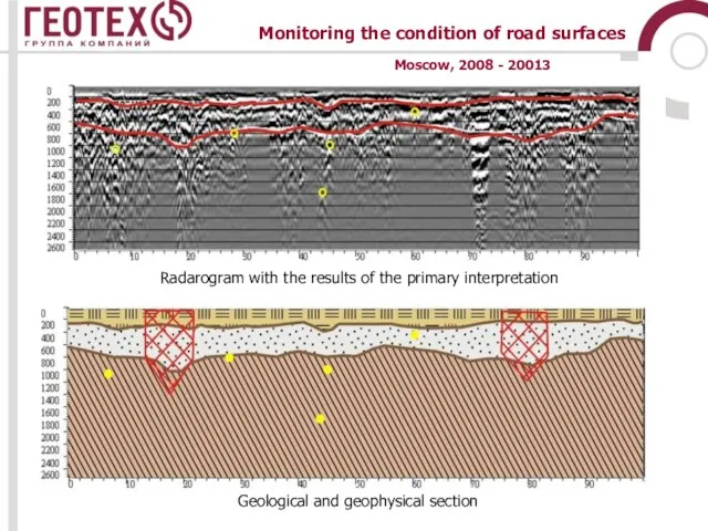
- 29. Cross section in pedestrian mode Moscow Roads, 2008 – 2013 Road monitoring
- 30. Monitoring the condition of road surfaces Geological and geophysical section Radarogram with the results of the
- 32. Скачать презентацию
Слайд 2Road monitoring
- determination of the thickness of pavement layers;
identification of subsidence
Road monitoring
- determination of the thickness of pavement layers;
identification of subsidence
Слайд 4Equipment for road monitoring
Antenna АB-2000R
Antenna АB-400R
Equipment for road monitoring
Antenna АB-2000R
Antenna АB-400R
Слайд 5
+7 495 641 2 641
www.geotech.ru
Horn antennas
АB-1000R
АB-400R
АB-1700R
АB-2500R
АB-2000R
+7 495 641 2 641
www.geotech.ru
Horn antennas
АB-1000R
АB-400R
АB-1700R
АB-2500R
АB-2000R
Слайд 6Antenna АB-2000R
Antenna АB-400R
Antenna АB-1000R
The distance between the surface and antenna
Antenna АB-2000R
Antenna АB-400R
Antenna АB-1000R
The distance between the surface and antenna
Слайд 7Multichannel GPR complex
The speed of survey - up to 80 km/hour
Dual channelы
Multichannel GPR complex
The speed of survey - up to 80 km/hour
Dual channelы
Слайд 8GPR ОКО-3 for road monitoring
GPR ОКО-3 for road monitoring
Слайд 9
+7 495 641 2 641
www.geotech.ru
SEMI-AUTOMATIC ASPHALT CONCRETE BOTTOM DEFINITION
GeoScan32 Software
+7 495 641 2 641
www.geotech.ru
SEMI-AUTOMATIC ASPHALT CONCRETE BOTTOM DEFINITION
GeoScan32 Software
Слайд 10Radarogramma (antenna AB-2000R)
Radarogramma (antenna AB-2000R)
Слайд 11Special Software «Asphalt» GeoScan32
:
measurement of the thickness of the top layer
Special Software «Asphalt» GeoScan32
:
measurement of the thickness of the top layer
Слайд 12
+7 495 641 2 641
www.geotech.ru
ONLINE DEFINITION OF ASPHALT CONCRETE LAYER THICKNESS
+7 495 641 2 641
www.geotech.ru
ONLINE DEFINITION OF ASPHALT CONCRETE LAYER THICKNESS
Слайд 13
+7 495 641 2 641
www.geotech.ru
REPORT(the thickness of asphalt concrete)
+7 495 641 2 641
www.geotech.ru
REPORT(the thickness of asphalt concrete)
Слайд 14
+7 495 641 2 641
www.geotech.ru
Determination of soil heterogeneity and structural layers, pavement.
Acceleration
+7 495 641 2 641
www.geotech.ru
Determination of soil heterogeneity and structural layers, pavement.
Acceleration
Слайд 15
+7 495 641 2 641
www.geotech.ru
Software «Analysis 7»
+7 495 641 2 641
www.geotech.ru
Software «Analysis 7»
Слайд 16Route on the map
You can choose the type of display: map
Route on the map
You can choose the type of display: map
Слайд 17Analysis of layer thicknesses in the software "Analysis 7
Analysis of layer thicknesses in the software "Analysis 7
Слайд 18
+7 495 641 2 641
www.geotech.ru
THE RESULT OF INTERPRETATION IN THE ANALYSIS PROGRAM
+7 495 641 2 641
www.geotech.ru
THE RESULT OF INTERPRETATION IN THE ANALYSIS PROGRAM
Слайд 19
+7 495 641 2 641
www.geotech.ru
THE RESULT OF INTERPRETATION IN THE ANALYSIS PROGRAM
+7 495 641 2 641
www.geotech.ru
THE RESULT OF INTERPRETATION IN THE ANALYSIS PROGRAM
Слайд 20The result of automatic interpretation of radarograms
The result of automatic interpretation of radarograms
Слайд 21The result of automatic interpretation of radarograms
The result of automatic interpretation of radarograms
Слайд 22Moscow area., АB-2000R3
Radarogramma (November 2019г)
Car with AB-2000R for sounding (November 2019)
Signal reflected
Moscow area., АB-2000R3
Radarogramma (November 2019г)
Car with AB-2000R for sounding (November 2019)
Signal reflected
Слайд 23The result of auto-picking of pavement layers in the Analysis 7 software
Moscow
The result of auto-picking of pavement layers in the Analysis 7 software
Moscow
Слайд 24Moscow, АБ-2000R3
Signals reflected from the road surface
Asphalt concrete
Georadar survey by antenna AB-1000R3
Moscow, АБ-2000R3
Signals reflected from the road surface
Asphalt concrete
Georadar survey by antenna AB-1000R3
Слайд 25Moscow
definition of pavement structure
identification of hidden defects
determination of the type of cracks
Asphalt
Moscow
definition of pavement structure
identification of hidden defects
determination of the type of cracks
Asphalt
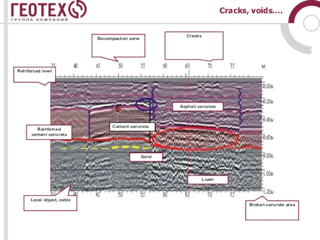
Слайд 26Cracks, voids….
Cracks, voids….
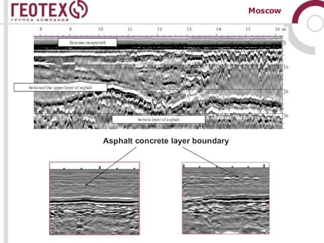
Слайд 27Moscow
Asphalt concrete layer boundary
Moscow
Asphalt concrete layer boundary
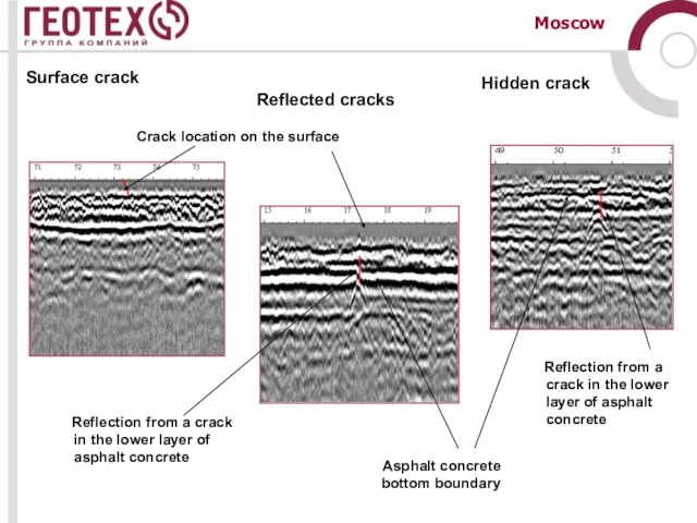
Слайд 28Moscow
Crack location on the surface
Asphalt concrete bottom boundary
Reflection from
Moscow
Crack location on the surface
Asphalt concrete bottom boundary
Reflection from
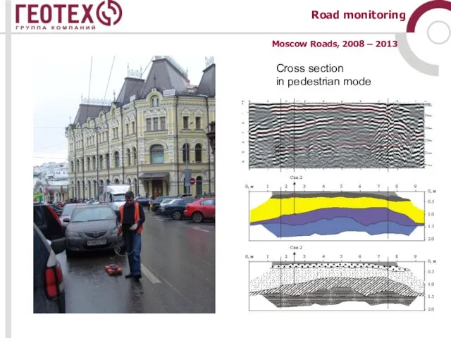
Слайд 29Cross section
in pedestrian mode
Moscow Roads, 2008 – 2013
Road monitoring
Cross section
in pedestrian mode
Moscow Roads, 2008 – 2013
Road monitoring
Слайд 30Monitoring the condition of road surfaces
Geological and geophysical section
Radarogram with the results
Monitoring the condition of road surfaces
Geological and geophysical section
Radarogram with the results
 Компания Мир плитки
 АУДИТ САЙТА
  Автоматизированное рабочее место
  БАРС.Web- Здравоохранение
 Graffiti: Art or vandalism
 Интегрированный урок. Окружающий мир + технология. 3 класс.
 Вербное воскресение
 Обстоятельство (5 класс)
 Почему молодые парни не хотят служить в армии?
 Прохождение строительной экспертизы проектной документации
 Каталог антуриумов
 Тема. Организация и техника внешнеэкономических операций по купле-продаже лицензий и по международному обмену инженерно-техниче
 СОСТОЯНИЕ И ПЕРСПЕКТИВЫ ИНТЕРНЕТ-РЕКЛАМЫ В РОССИИ
 Темпераменты Борец
 Природная Зональность
 Монтажная структура фильма
 Системы автоматического управления
 Реальность и фантазии
 кулинарный поединок
 Разработка и внедрение программы энергосбережения городского округа г. ДзержинскЕ.А. Чичеров, к.э.н.Руководитель дирекции по ЦФО
  Сибирские интернет-недели 2011
 Презентация на тему Сокращение таможен и внешней торговли России
  Проекты как средство сохранения единства библиотечного сообщества Вологодчины
 "ЖИВИ, РОДНОЙ ЯЗЫК!"
 Эко 9кл. Приспособительные формы организмов
 Международная конференция «НефтеГазСтандарт – 2007»11 – 12 сентября 2007 г., г. Астрахань
 Презентация на тему Мир древности: далёкий и близкий
  Презентация на тему Права ученика в школе