- Jakarta floods

Содержание
- 2. Jakarta flood management Part 1: The basics - Spatial Planning Part 2: The flood of February
- 3. Part 1 The basics: Spatial planning “We live in a changing world” The World Bank
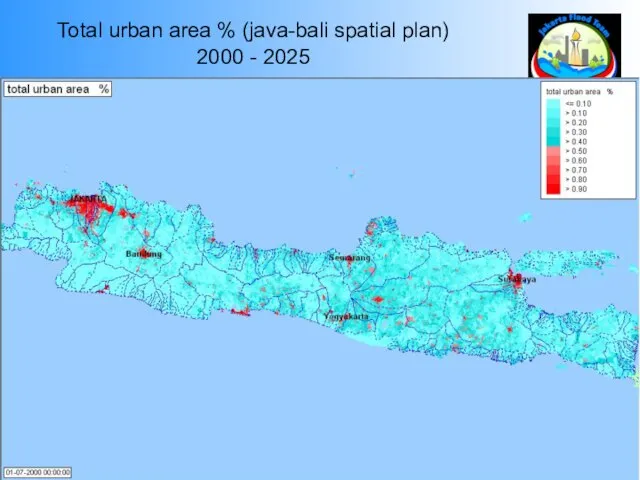
- 4. Total urban area % (java-bali spatial plan) 2000 - 2025
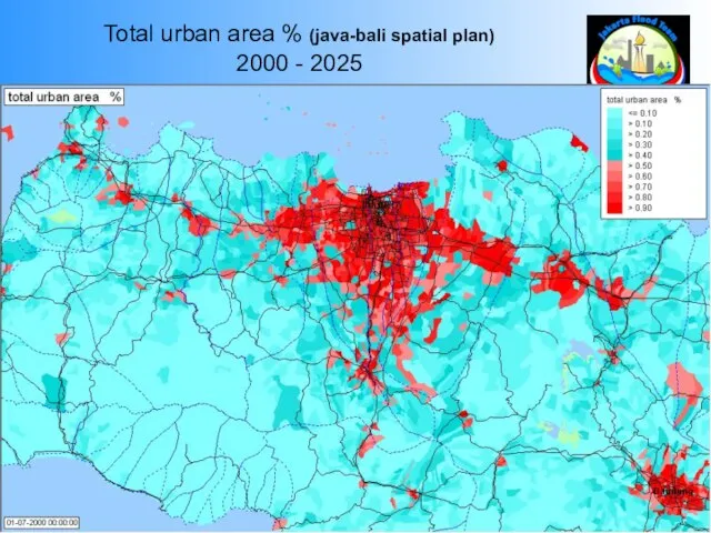
- 5. Total urban area % (java-bali spatial plan) 2000 - 2025
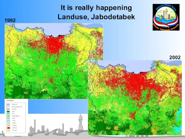
- 6. It is really happening Landuse, Jabodetabek 1992 2002
- 7. It is really happening Urban area, G. Pangrango 1992 - 2001 The World Bank
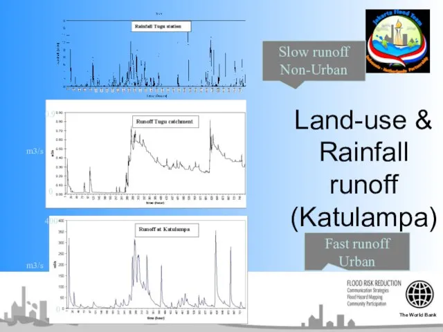
- 8. Land-use & Rainfall runoff (Katulampa) 0 400 0 0.9 m3/s m3/s Fast runoff Urban Slow runoff
- 9. Part 2 Flood February 2007 Hydrology The World Bank
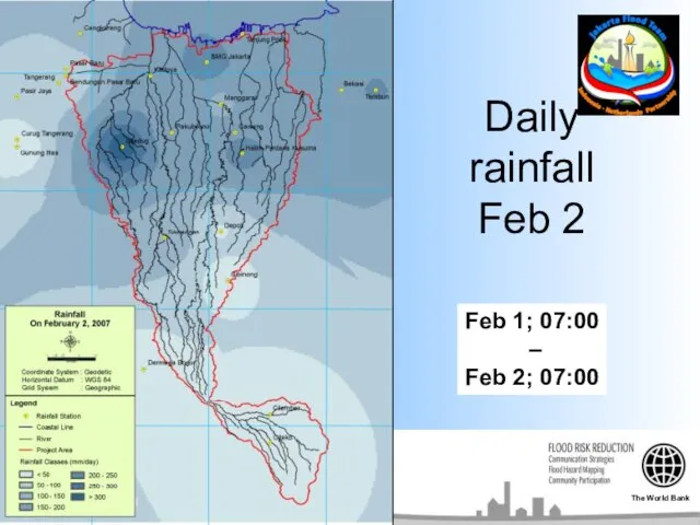
- 10. Daily rainfall Feb 2 Feb 1; 07:00 – Feb 2; 07:00 The World Bank
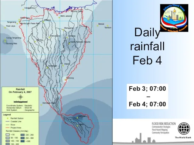
- 11. Daily rainfall Feb 4 Feb 3; 07:00 – Feb 4; 07:00 The World Bank
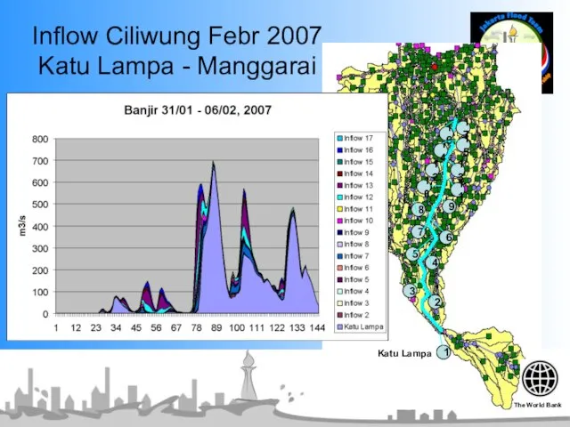
- 12. Inflow Ciliwung Febr 2007 Katu Lampa - Manggarai 1 2 3 5 6 7 8 9
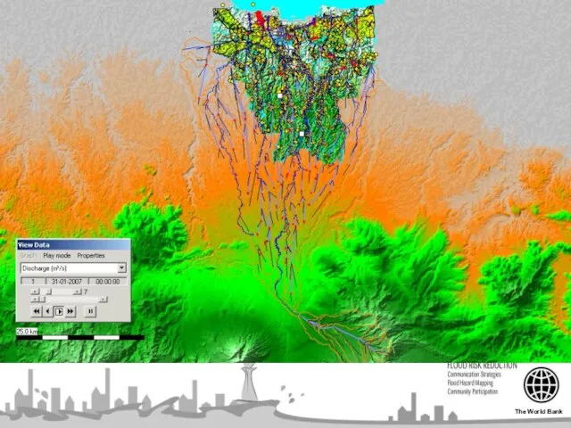
- 13. Flood February 2007 Hydraulics & Flood extent Unique “Complete upstream-downstream flood modelling framework now available for
- 14. The World Bank
- 15. The World Bank
- 16. The World Bank
- 17. West Banjir canal
- 18. Part 3 No-regret ST Measures Rehabilitation “Restore original-available design capacity” -Dredging -Dike improvement The World Bank
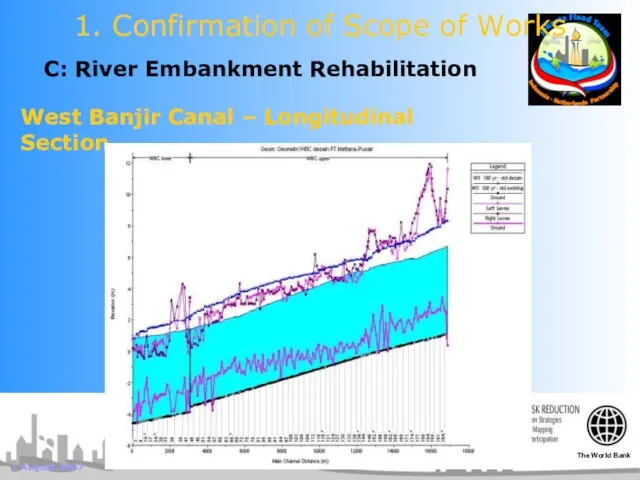
- 19. 1 August 2007 C: River Embankment Rehabilitation 1. Confirmation of Scope of Works West Banjir Canal
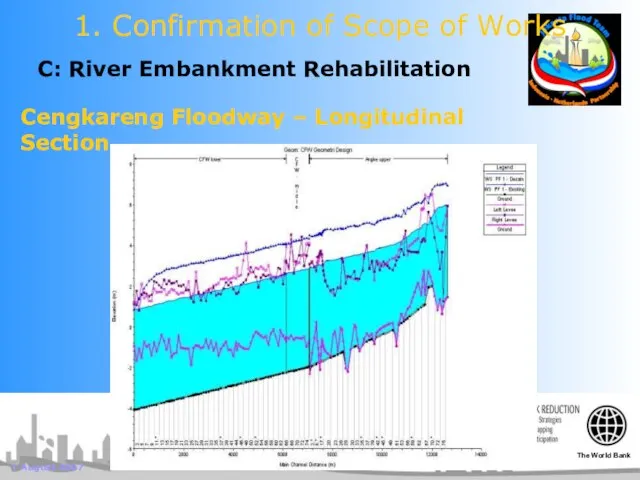
- 20. 1 August 2007 C: River Embankment Rehabilitation 1. Confirmation of Scope of Works Cengkareng Floodway –
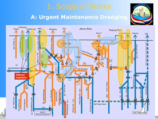
- 21. A: Urgent Maintenance Dredging 1. Scope of Works
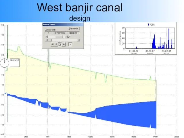
- 22. West banjir canal design
- 23. No-regret ST Measures “East-Banjir Canal” The World Bank
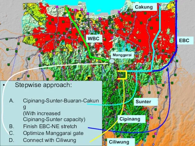
- 24. Stepwise approach: Cipinang-Sunter-Buaran-Cakung (With increased Cipinang-Sunter capacity) Finish EBC-NE stretch Optimize Manggarai gate Connect with Ciliwung
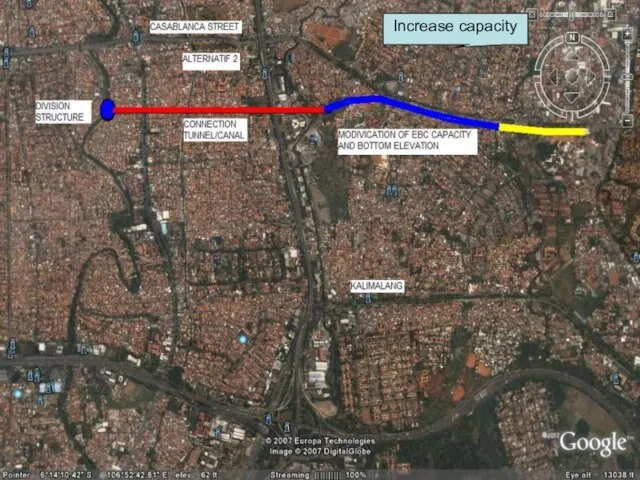
- 25. Increase capacity
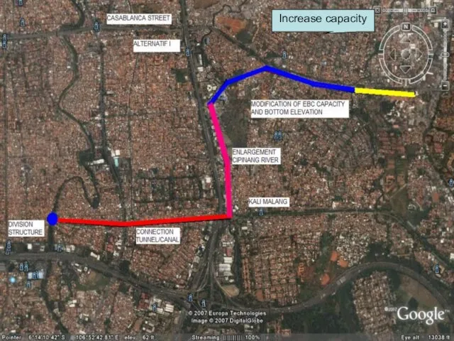
- 26. Increase capacity
- 27. No-regret ST Measures EBC-CAK-CIL-Manggarai Simulation 2007 The World Bank
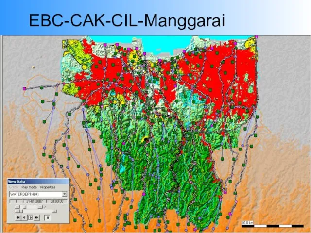
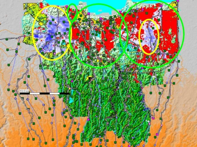
- 28. EBC-CAK-CIL-Manggarai
- 30. Part 4 Tidal analysis High Tide floods The World Bank
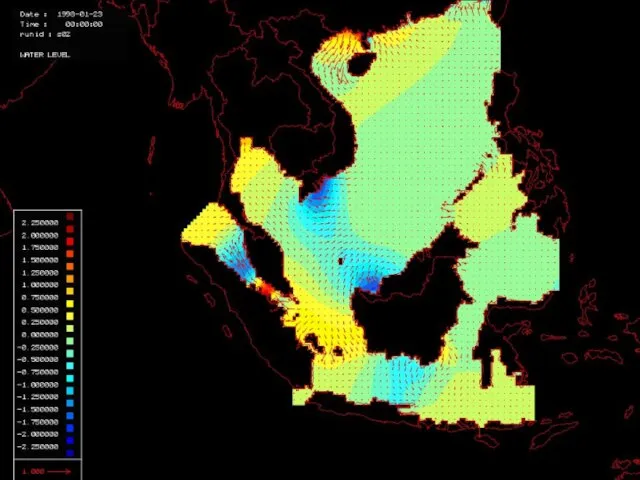
- 31. Animation of tide in South China Sea
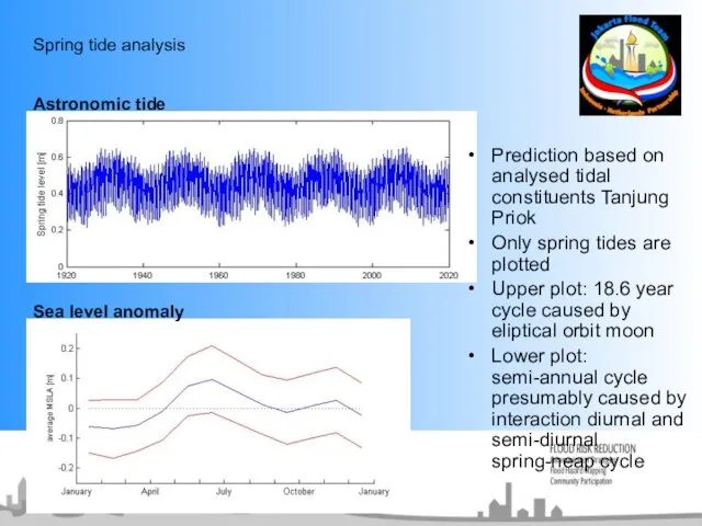
- 32. Spring tide analysis Prediction based on analysed tidal constituents Tanjung Priok Only spring tides are plotted
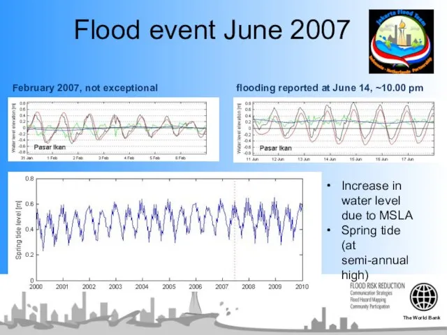
- 33. Flood event June 2007 Increase in water level due to MSLA Spring tide (at semi-annual high)
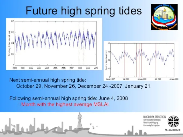
- 34. Future high spring tides Next semi-annual high spring tide: October 29, November 26, December 24 -2007,
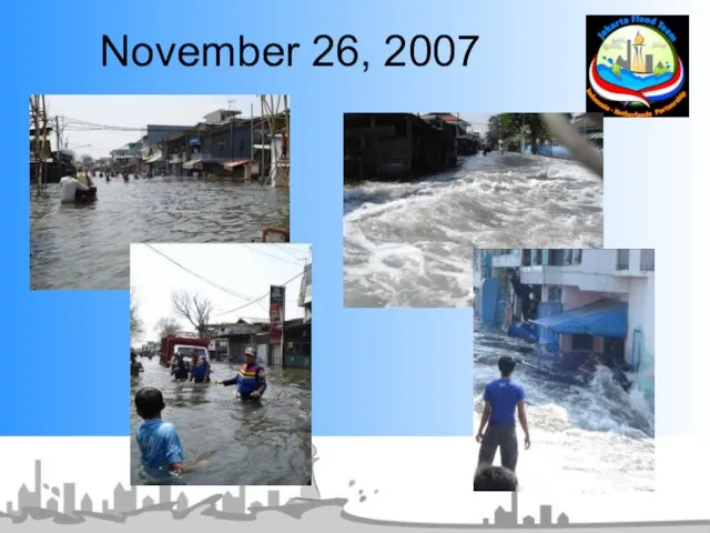
- 35. November 26, 2007
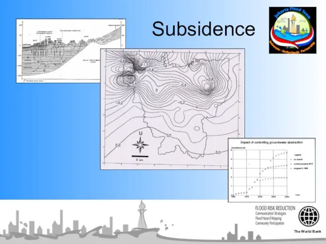
- 36. Subsidence The World Bank
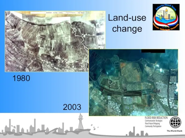
- 37. 1980 2003 Land-use change The World Bank
- 38. Pluit 1989, 2007, 2025 (Positive view) Pasar Ikan cm Nov 1989 Nov 2007 Nov 2025 Nov
- 39. Pasar Ikan cm Nov 1989 Nov 2007 Nov 2025 Nov 26, 2007 Oct 29, 2007 subsidence
- 40. High tide floods 2007: “Signs of a sinking Jakarta” The World Bank
- 41. Jadebotabek Water Resources Management Study (JWRMS,1994) The World Bank
- 42. Part 5 “Strong knowledge base” “Short-term action” The World Bank
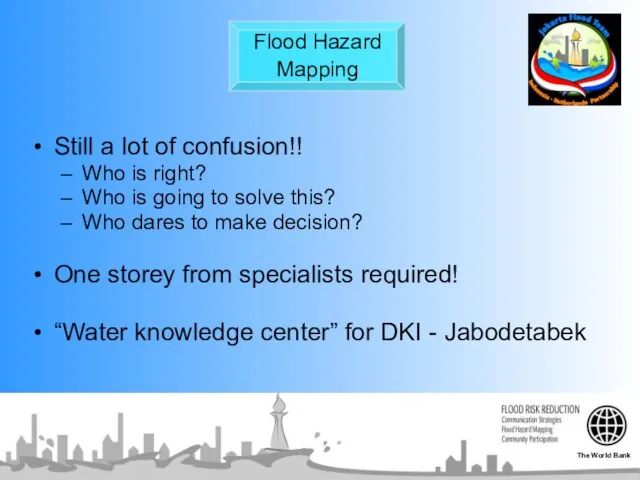
- 43. Flood Hazard Mapping Still a lot of confusion!! Who is right? Who is going to solve
- 44. Part 5 Actions and Financing mechanism The World Bank
- 45. ACTION PLAN Short Term: Dredging / East Banjir Canal / Manggarai Gate Stop Ground Water Extraction
- 46. ACTION PLAN Medium Term: Bulk Water Supply Stop Ground Water Extraction (household) Solid Waste Management Low
- 47. ACTION PLAN Long Term: Water Quality Water Retention Basin / Catchment Area / Sea Defense Land
- 49. Скачать презентацию
Слайд 3
Part 1
The basics: Spatial planning
“We live in a changing world”
The World Bank
Part 1
The basics: Spatial planning
“We live in a changing world”
The World Bank
Слайд 4Total urban area % (java-bali spatial plan)
2000 - 2025
Total urban area % (java-bali spatial plan)
2000 - 2025
Слайд 5Total urban area % (java-bali spatial plan)
2000 - 2025
Total urban area % (java-bali spatial plan)
2000 - 2025
Слайд 6It is really happening
Landuse, Jabodetabek
1992
2002
It is really happening
Landuse, Jabodetabek
1992
2002
Слайд 7It is really happening
Urban area, G. Pangrango
1992 - 2001
The World Bank
It is really happening
Urban area, G. Pangrango
1992 - 2001
The World Bank

Слайд 8Land-use & Rainfall runoff (Katulampa)
0
400
0
0.9
m3/s
m3/s
Fast runoff
Urban
Slow runoff
Non-Urban
The World Bank
Land-use & Rainfall runoff (Katulampa)
0
400
0
0.9
m3/s
m3/s
Fast runoff
Urban
Slow runoff
Non-Urban
The World Bank
Слайд 9
Part 2
Flood February 2007
Hydrology
The World Bank
Part 2
Flood February 2007
Hydrology
The World Bank
Слайд 10Daily
rainfall
Feb 2
Feb 1; 07:00
–
Feb 2; 07:00
The World Bank
Daily
rainfall
Feb 2
Feb 1; 07:00
–
Feb 2; 07:00
The World Bank
Слайд 11Daily
rainfall
Feb 4
Feb 3; 07:00
–
Feb 4; 07:00
The World Bank
Daily
rainfall
Feb 4
Feb 3; 07:00
–
Feb 4; 07:00
The World Bank
Слайд 12Inflow Ciliwung Febr 2007
Katu Lampa - Manggarai
1
2
3
5
6
7
8
9
10
13
12
14
15
11
16
4
17
6
Katu Lampa
The World Bank
Inflow Ciliwung Febr 2007
Katu Lampa - Manggarai
1
2
3
5
6
7
8
9
10
13
12
14
15
11
16
4
17
6
Katu Lampa
The World Bank
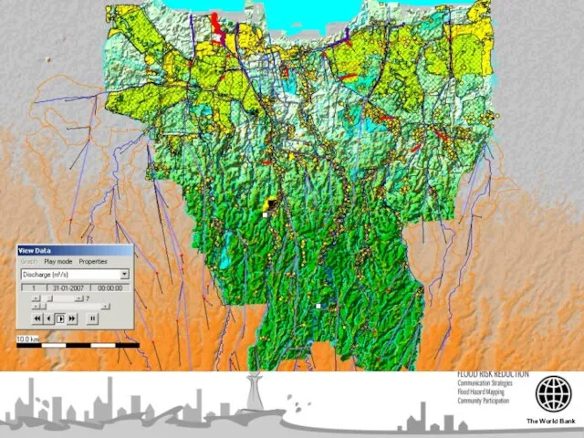
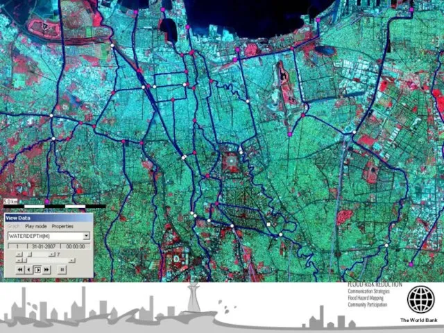
Слайд 13Flood February 2007
Hydraulics & Flood extent
Unique
“Complete upstream-downstream flood modelling framework now available
Flood February 2007
Hydraulics & Flood extent
Unique
“Complete upstream-downstream flood modelling framework now available
Слайд 14The World Bank
The World Bank
Слайд 15The World Bank
The World Bank
Слайд 16The World Bank
The World Bank
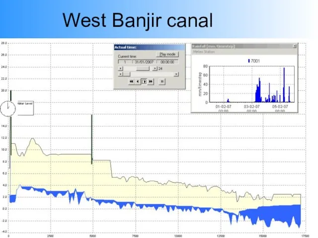
Слайд 17West Banjir canal
West Banjir canal
Слайд 18Part 3
No-regret ST Measures
Rehabilitation
“Restore original-available design capacity”
-Dredging
-Dike improvement
The World Bank
Part 3
No-regret ST Measures
Rehabilitation
“Restore original-available design capacity”
-Dredging
-Dike improvement
The World Bank
Слайд 191 August 2007
C: River Embankment Rehabilitation
1. Confirmation of Scope of Works
West Banjir
1 August 2007
C: River Embankment Rehabilitation
1. Confirmation of Scope of Works
West Banjir
Слайд 201 August 2007
C: River Embankment Rehabilitation
1. Confirmation of Scope of Works
Cengkareng Floodway
1 August 2007
C: River Embankment Rehabilitation
1. Confirmation of Scope of Works
Cengkareng Floodway
Слайд 21A: Urgent Maintenance Dredging
1. Scope of Works
A: Urgent Maintenance Dredging
1. Scope of Works
Слайд 22West banjir canal
design
West banjir canal
design
Слайд 23No-regret ST Measures
“East-Banjir Canal”
The World Bank
No-regret ST Measures
“East-Banjir Canal”
The World Bank
Слайд 24Stepwise approach:
Cipinang-Sunter-Buaran-Cakung
(With increased Cipinang-Sunter capacity)
Finish EBC-NE stretch
Optimize Manggarai gate
Connect with Ciliwung
WBC
EBC
Cakung
Sunter
Cipinang
Manggarai
Ciliwung
Stepwise approach:
Cipinang-Sunter-Buaran-Cakung
(With increased Cipinang-Sunter capacity)
Finish EBC-NE stretch
Optimize Manggarai gate
Connect with Ciliwung
WBC
EBC
Cakung
Sunter
Cipinang
Manggarai
Ciliwung
Слайд 25Increase capacity
Increase capacity
Слайд 26Increase capacity
Increase capacity
Слайд 27No-regret ST Measures
EBC-CAK-CIL-Manggarai Simulation 2007
The World Bank
No-regret ST Measures
EBC-CAK-CIL-Manggarai Simulation 2007
The World Bank
Слайд 28EBC-CAK-CIL-Manggarai
EBC-CAK-CIL-Manggarai
Слайд 30Part 4
Tidal analysis
High Tide floods
The World Bank
Part 4
Tidal analysis
High Tide floods
The World Bank
Слайд 31Animation of tide in South China Sea
Animation of tide in South China Sea
Слайд 32Spring tide analysis
Prediction based on analysed tidal constituents Tanjung Priok
Only spring
Spring tide analysis
Prediction based on analysed tidal constituents Tanjung Priok
Only spring
Слайд 33Flood event June 2007
Increase in water level due to MSLA
Spring tide (at
Flood event June 2007
Increase in water level due to MSLA
Spring tide (at
Слайд 34Future high spring tides
Next semi-annual high spring tide:
October 29, November 26,
Future high spring tides
Next semi-annual high spring tide:
October 29, November 26,
Слайд 35November 26, 2007
November 26, 2007
Слайд 36Subsidence
The World Bank
Subsidence
The World Bank
Слайд 371980
2003
Land-use change
The World Bank
1980
2003
Land-use change
The World Bank
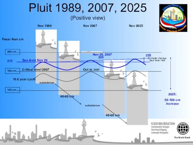
Слайд 38Pluit 1989, 2007, 2025
(Positive view)
Pasar Ikan cm
Nov 1989
Nov 2007
Nov 2025
Nov 26, 2007
Oct
Pluit 1989, 2007, 2025
(Positive view)
Pasar Ikan cm
Nov 1989
Nov 2007
Nov 2025
Nov 26, 2007
Oct
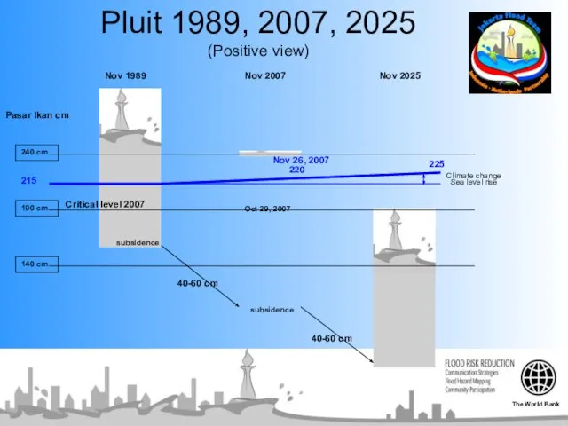
Слайд 39Pasar Ikan cm
Nov 1989
Nov 2007
Nov 2025
Nov 26, 2007
Oct 29, 2007
subsidence
40-60 cm
40-60 cm
Climate
Pasar Ikan cm
Nov 1989
Nov 2007
Nov 2025
Nov 26, 2007
Oct 29, 2007
subsidence
40-60 cm
40-60 cm
Climate
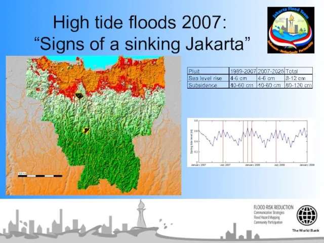
Слайд 40High tide floods 2007:
“Signs of a sinking Jakarta”
The World Bank
High tide floods 2007:
“Signs of a sinking Jakarta”
The World Bank
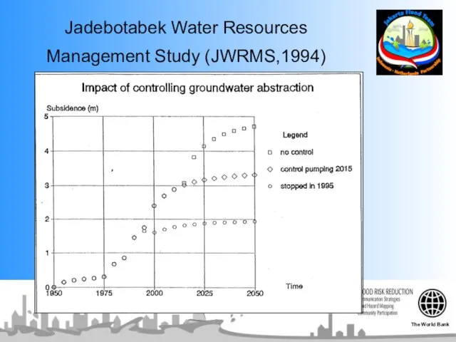
Слайд 41Jadebotabek Water Resources Management Study (JWRMS,1994)
The World Bank
Jadebotabek Water Resources Management Study (JWRMS,1994)
The World Bank
Слайд 42Part 5
“Strong knowledge base”
“Short-term action”
The World Bank
Part 5
“Strong knowledge base”
“Short-term action”
The World Bank
Слайд 43Flood Hazard
Mapping
Still a lot of confusion!!
Who is right?
Who is going
Flood Hazard
Mapping
Still a lot of confusion!!
Who is right?
Who is going
Слайд 44Part 5
Actions and Financing mechanism
The World Bank
Part 5
Actions and Financing mechanism
The World Bank
Слайд 45ACTION PLAN
Short Term:
Dredging / East Banjir Canal / Manggarai Gate
Stop Ground Water
ACTION PLAN
Short Term:
Dredging / East Banjir Canal / Manggarai Gate
Stop Ground Water
Слайд 46ACTION PLAN
Medium Term:
Bulk Water Supply
Stop Ground Water Extraction (household)
Solid Waste Management
Low Income
ACTION PLAN
Medium Term:
Bulk Water Supply
Stop Ground Water Extraction (household)
Solid Waste Management
Low Income
Слайд 47ACTION PLAN
Long Term:
Water Quality
Water Retention Basin / Catchment Area / Sea Defense
Land
ACTION PLAN
Long Term:
Water Quality
Water Retention Basin / Catchment Area / Sea Defense
Land
 Интерактивный квест Спасение эйленов
 ОФБУ как форма управления активами
 Педагогические колледжи Красноярского края
 Осторожно огонь
 Требования, предъявляемые к лицам, назначаемым на должности прокуроров
 А. Куприн «Слон»
 Что изменилось в отчетности за 9 месяцев: Декларация по НДС и прослеживаемость товаров
 Презентация на тему Вред здоровью человека от сотового телефона
  «Роль игры в развитии речи дошкольника»
 Спорт среди молодежи в Красноярске
 Лувр
Лувр Государственная поддержка субъектов предпринимательства в Республике Казахстан со стороны АО «Фонд «Даму»
 Моделирование при разработке управленческих решений. Разработка управленческого решения
 Как на самом деле любить детей. «Именно любовь делает человека таким, каким он должен быть.» Подготовила воспитатель Кори
 Страницы истории
  Презентация на тему Петр 1
 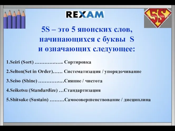 5S: Сортировка. Систематизация. Сияние. Стандартизация. Самосовершенствование
 Использование современных образовательных технологий в процессе обучения русскому языку
 Медведев Егор Бийск ОПШ 2022 (1) (1)
 Россия выбирает президента
 Изображение головы человека в пространстве
 Искусство раннего Возрождения
 Проверка домашнего задания
 Новая сказка про Красную Шапочку
 Танковая навигационная аппаратура
 Social and personality development and types of play pre-school years
  Презентация на тему ЗУНР Западно-Украинская Народная Республика
  Спин - HIV